Cedar Creek Lake water depth
& boat access.
Before buying a waterfront home or lot, ask a more useful question than “Is it deep water?” Ask how much usable water is at the boat slip and along the route to open water—and at what lake level those measurements were taken.
An appraisal perspective from Ronald E. Dunham, MAI, Dunham Commercial Appraisers · Updated October 25, 2026.
What’s the lake level?
Conservation pool reference: 322.00 ft NGVD29.
Feet NGVD29—not the depth at a dock.
Lake level is not dock depth. Water depth varies by location. A reading below full pool describes the water-surface change, not the amount of water remaining at your property.
How much water would remain at my dock? ↗
Source: USGS gauge 08063010, Cedar Creek Reservoir near Trinidad ↗. Readings may be provisional and revised. This site checks the feed as needed, caches successful readings for up to one hour, and refreshes the display while this page is open. Data over three hours old is flagged; data over 24 hours old is not displayed. This is not navigation or flood-safety guidance.
Official lake levels & history ↗ Understand water depth & boat access →
Lake level is not the same as water depth.
Lake level describes the elevation of the water surface. Depth describes the distance from that surface to the lake bottom at a particular place. Two docks can share the same water-surface elevation and have very different depths because the lake bottom is uneven.
The Texas Water Development Board lists Cedar Creek Reservoir’s conservation pool at 322 feet in the NGVD29 vertical datum. That is a reference elevation, not 322 feet of water beneath a boat. Use TWDB’s Cedar Creek Reservoir page for dated water levels and historical information. This article is not a live lake-level report.
Where does the lake get deeper?
Explore Cedar Creek Lake’s bottom contours to see the general pattern of deeper channels, shallow areas and changing slopes. Start with your part of the lake, then open the full-size map to zoom in.
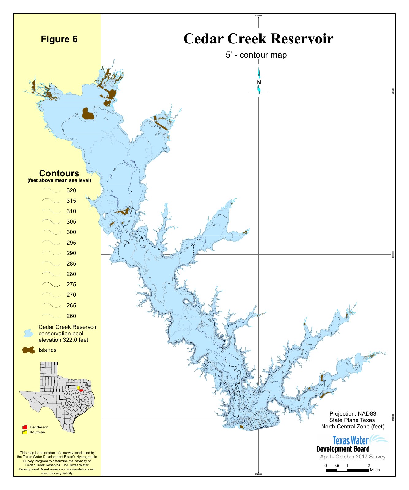
Read the numbers as elevations—not depths.
A line marked 315 represents a lake-bottom elevation of 315 feet. With the water surface at normal full pool, 322 feet NGVD29, the estimated depth along that contour would be 7 feet.
| Bottom elevation | Estimated water depth |
|---|---|
| 320 feet | 2 feet |
| 315 feet | 7 feet |
| 310 feet | 12 feet |
General reference—not a dock-depth measurement. The map uses 5-foot contours from a 2017 survey. It does not show today’s water depth or identify individual docks. Sediment, dredging and other changes may affect local conditions. TWDB states these survey maps are not intended for boating navigation or reservoir boundary determinations.
Open full-size contour map (PDF) ↗
Source: TWDB Cedar Creek survey publications. Preview reproduced from the official contour map; no agency endorsement implied.
What happens at a dock when the lake falls?
As a simple illustration, a slip with 8 feet of water at a stated reference lake level would have about 5 feet if the lake dropped 3 feet, assuming the lake bottom had not changed. Whether that is enough depends on the boat’s draft, an appropriate clearance allowance, the lift arrangement, and the shallowest part of the route away from the dock.
Try the dock-depth planning calculator ↗
Questions to ask about a waterfront property.
- Where was depth measured? The boat slip, end of the dock, cove entrance, and route to open water are different locations.
- When was it measured? Record both the measurement date and the corresponding lake elevation, using a consistent vertical datum.
- What boat needs access? Consider draft and clearance, not just a description such as “deep water.”
- What happens in lower-water conditions? Compare the reference level with historical lake levels; do not assume the last visit represents year-round access.
- What records are available? Review available surveys, shoreline documentation, permits, and any reliable depth measurements. A broad contour map is not a current sounding at the property.
Does deeper water make a property more valuable?
Water access is one consideration in a waterfront appraisal, alongside location, views, frontage, usable land, improvements, condition, and comparable sales. The market contribution of a particular access advantage must be supported by relevant evidence. A lakewide average or a subdivision name alone does not establish a depth premium.
Our supplied sales records do not include verified dock and approach depths. We therefore do not assign a dollar-per-foot adjustment or promise a particular subdivision’s boating conditions. Start with the home-sale comparisons or waterfront lot-sale summaries, then investigate the individual property.
Include the structures in your decision.
A useful location can still have a dock, lift, or shoreline wall that needs attention. Review condition and documentation separately from water depth. TRWD publishes permit resources and drawing requirements for docks, boathouses, and retaining walls. Confirm requirements for the particular project with the responsible agency.
Explore boathouse, dock and retaining-wall ownership costs →
Need a closer look at a lake property?
Discuss an independent appraisal or a defined sales-analysis assignment with Ron. Scope, information needs, fee and delivery are agreed individually. This guide is not a navigation survey, engineering inspection, or property-specific appraisal.
Sources: Texas Water Development Board, Water Data for Texas; Tarrant Regional Water District permit resources. Links checked October 25, 2026. Agency links do not imply endorsement.